RESTORE+: Addressing Landscape Restoration on Degraded Land in Indonesia and Brazil
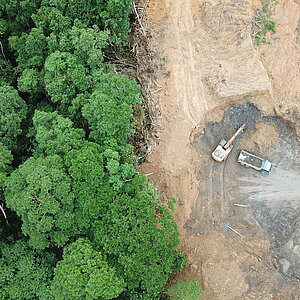
Although crucial for many activities, the availability and accessibility of map data in Brazil and Indonesia are often limited. This limitation hampers detailed planning of forest and landscape restoration, as well as mobilization of financial and institutional resources that require baseline setting and monitoring of results. In the context of avoiding deforestation, data limitation will also result in limited ability to participate in markets that incentivize/enforce sustainable practices. The project aims to deliver mapping technologies to help key actors access high-quality data in planning, mobilizing funds, and implementing efforts to avoid deforestation and restore degraded forests and landscapes. Additionally, the project will also derive insights for national policies and long-term strategies to further demonstrate the multiplier effect of high-quality map data towards increased capacity for delivering land use sustainability.
- Countries
- Brazil, Indonesia
- IKI funding
- 12,498,171.00 €
- Duration
- 03/2017 till 12/2028
- Status
- open
- Implementing organisation
- International Institute for Applied Systems Analysis (IIASA)
- Political Partner
-
- Brazilian Cooperation Agency (ABC)
- National Research and Innovation Agency (BRIN) - Indonesia
- Implementing Partner
-
- SELPER Brazil
- World Agroforestry Center (ICRAF)
- Online
State of implementation/results
- Following the Evolving Participatory Information System for Nature based Climate Solutions (Epistem) pilot consultation in February 2025 in South Sumatra (Indonesia), a kick-off meeting in April established collaboration with the Social Forestry and Environmental Partnership Office of South Sumatra under the Ministry of Forestry. This partnership will equip field surveyors in protected forest areas with mobile applications for in-situ data collection, enabling detailed mapping of “difficult-to-map” land uses such as agroforestry, smallholder commodities, and mixed farms. The resulting granular data will support EUDR (EU Deforestation Regulation) compliance, empower sustainable smallholder agriculture, and promote forest conservation and landscape restoration.
- In June 2025, the community of landscape studies practitioners (KARSA BENTALA) was officially formed as a collaborative forum supported by Epistem. A second meeting in early August focused on aligning understanding of landscape monitoring via remote sensing, laying the foundation for strengthening members’ technical capacity and building a collaborative network for sustainable landscape management in South Sumatra. The event enhanced participants’ basic understanding of satellite imagery and validated the first iteration of the Epistem mockup. Efforts are ongoing to further improve technical capacity and standardize data collection strategies.
- Two additional pilot collaborations are planned for January 2026 in South Sulawesi (Indonesia) and East Nusa Tenggara (Indonesia) to ensure the nationwide relevance of the open-source mapping tool. The project will focus on these pilots to co-develop a prototype scheduled for launch in May 2026.
- In Brazil, development and testing have been ongoing for the software required to estimate the Rural Environmental Registry (CAR) based on the data currently available. Full implementation of the CAR in Brazil is necessary to support Brazil’s emission reduction goals. The team is working to improve the first version of the geospatial database associated to CAR, so that it will be as complete as possible when delivered to the stakeholders in early 2026. This work is done with the support and request of MMA (Ministry for Environment and Climate Change) and MGI (Ministry of Management and Innovation in Public Services). Currently, MGI is responsible for the CAR.
- At the request of MMA, the RESTORE+ team is supporting the National Institute for Space Research (INPE) in modernising its systems for monitoring deforestation in Amazonia, using the Open-Source-Software SITS developed by the project. This effort involves capacity development and training for the INPE team, and the development of customised software to support INPE’s needs.
- Currently, at the request of MMA and the Ministry of Science, Technology and Innovation (MCTI), the RESTORE+ team is producing annual land use and land cover maps for Brazil from 2000 to 2025. This dataset will be used to produce Brazil’s National Inventory of greenhouse gas (GHG) Emissions and to establish a strong baseline for measuring Brazil’s compliance with its recently renewed and improved Nationally Determined Contributions (NDCs) goals.
- At the request of MMA, the RESTORE+ team is also adapting the MagPIE land use model, developed by the Potsdam Institute for Climate Change (PIK), to model Brazil’s current and long-term emissions scenarios from the Agriculture, Land Use and Forestry sector (AFOLU). This sector accounts for over 70% of the country’s GHG emissions.
Latest Update:
04/2026
Further links
Project relations
Legend:
The link has been copied to the clipboard