Biodiversity Conservation in Wetlands through Integrated Water Resources Management
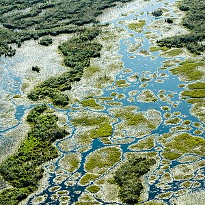
Tanzania has 115 recognized wetlands, covering around ten percent of the country’s land area. They are species-rich and productive ecosystems that provide important services, such as freshwater. However, about 90 percent of these areas are threatened by unsustainable water use and intensive agriculture. The project strengthens partner organisations to better manage water resources and ecosystems, helping to conserve biodiversity. It improves water governance by building the capacities of relevant institutions in integrated water resources management. At the same time, it promotes more efficient water use, for example in irrigation, and supports ecosystem-based adaptation in the upper Katuma River to maintain ecological minimum flows. In addition, the project shares experiences and approaches so they can be applied in Tanzania and internationally. This way, it contributes to the implementation of the national biodiversity strategy and targets of the Global Biodiversity Framework.
- Countries
- Tanzania
- IKI funding
- 4,000,000.00 €
- Duration
- 01/2024 till 05/2027
- Status
- open
- Implementing organisation
- Deutsche Gesellschaft für Internationale Zusammenarbeit (GIZ) GmbH
- Political Partner
-
- Ministry of Water and Irrigation, MoWI - Tanzania
- Implementing Partner
-
- International Union for Conservation of Nature and Natural Resources (IUCN) - Eastern and Southern Africa Regional Office
- Rikolto in East Africa
- SNV Netherlands Development Organisation - Tanzania
State of implementation/results
- Improved governance, coordination & land-use planning:
- High-level consultations with District Executive Directors of Tanganyika and Nsimbo secured commitment to integrated land and water governance aligned with national integrated water resource management (IWRM) reforms and Vision 2050
- Needs assessments with 70 stakeholders across three Water User Associations (WUAs) identified governance gaps and informed tailored capacity-building programmes
- Two Village Land Use Plans (Katuma, Usense) were approved with 57 by-laws, designating zones for sustainable agriculture (11,300 ha), irrigation (1,226 ha), pasture (2,120 ha), forest reserves (3,936 ha) and water protection (627 ha), embedding biodiversity safeguards into local governance
- Strengthened institutional & technical capacity for water & ecosystem management:
- Hydrological and biodiversity monitoring systems were upgraded through updated rating curves, an environmental flows framework for the Katuma River, and procurement of real-time kinematic positioning surveying equipment and a drone
- River channel engineering designs were refined using stabilisation and nature-based solutions
- Two restoration sites (Misukumilo, Kakese) were established with 60 m buffer zones and tree and grass planting to reduce erosion and siltation
- Expanded inclusive participation & community-based monitoring:
- 49 village committee members and 220 community members were trained on conservation and land governance
- 58 WUA and community members now operate river health monitoring teams on the Katuma, Msaginya and Mpanda rivers using standardised biotope sampling and TARISSfupi scoring
- Promoted sustainable water use, agriculture & pollution control:
- Six demonstration plots (five rice, one horticulture) promoted drip irrigation, wetting-and-drying techniques and improved seeds
- Training of 103 Trainers of Trainers and 15 extension officers on IWRM and regenerative agriculture reached up to 12,000 water users
- Six training sessions reached 1,830 farmers and miners on safe chemical use and disposal
- Three chemical collection centres were established and mechanical weeding promoted to reduce chemical and water use
- Generated biodiversity evidence & operational knowledge for IWRM:
- The first integrated dry-season biodiversity assessment in the Katuma Catchment and Katavi National Park documented 76 plant, 98 bird and 20 mammal species, including large hippo (1,724) and crocodile (621) populations
- Standardised tools produced spatial datasets and diversity indices, establishing a replicable long-term monitoring system and identifying priority risks (riparian degradation, erosion, sedimentation, livestock pressure, illegal abstraction) to guide targeted restoration and riparian management
- Strengthened cross-institutional capacity and policy engagement:
- 23 staff from basin authorities, research institutes, protected areas, districts, communities and NGOs were trained in biodiversity monitoring, GPS, Kobo Toolbox and ecological reporting
- Project results contributed to national water and biodiversity policy dialogue through three different fora and were presented at the TAWIRI Scientific Conference (Dec 2025)
Latest Update:
07/2026
Project relations
Legend:
The link has been copied to the clipboard